JOHN S. ALLEN'S BICYCLE FACILITIES, LAWS AND PROGRAMS PAGES |
||
 |
Top: home page |  |
JOHN S. ALLEN'S BICYCLE FACILITIES, LAWS AND PROGRAMS PAGES |
||
|
Top: home page | |
Suburban sprawl
|
John S. Allen photo |
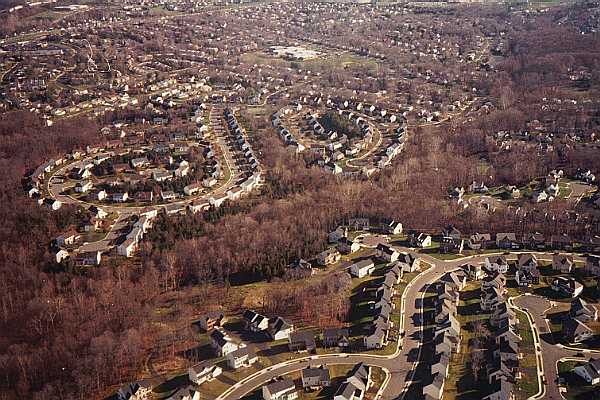
I took the photo on a flight path into Dulles International Airport, over Chantilly, Virginia. The large, low building in the top center of the picture is a school. Consider how your child would get to that school if you lived in one of the houses in the foreground. Your child would probably ride a school bus, provided at considerable expense to the community. You may also view a satellite photo of this location on Google Maps. The school is at the right side of the satellite photo. The view in my photo is from left to right (west to east) across the satellite photo. If you scroll down a little in the satellite photo, you can see roads that connect. The distance along roads from the houses in the foreground to the school is twice the distance as the crow flies. The sidewalk on the arterial street in front of the housing development is discontinuous. The school would be an easy bicycle ride away -- even an easy walk -- with a reasonably direct route. (And there may be something approaching that in this example -- read on.) Much suburban residential development in the United States is like this, with only informal connectivity on dirt paths, if any. Lack of connectivity reflects a lack of coordination between different developers, and a lack of vision and leadership by local government. This situation also reflects the preferences of residents to some degree, by keeping through motor traffic out of residential areas. But the baby has been thrown out with the bathwater, so to speak. A house you can see out your back window could be a mile or two away by road, or by any route that avoids trespassing on the private property of strangers. Arterial streets may -- and should -- have wide outside lanes, shoulders or bike lanes to allow bicycles and motor vehicles to share them comfortably, and have traffic signals that work well for bicyclists. Bicyclists must ride on the arterial streets, or cross them, for some trips, especially, longer trips. But residents should not have to take a long trip around on the arterial streets to get to a neighbor's house they can see out their back window! If you enlarge the satellite photo, you may notice some paths in the parkland behind the houses. Many of them appear unpaved. There also appear to be a couple of bridges across the stream that runs through the woods. A Microsoft Live Maps view shows a bridge, or at least the footings for one, connecting to a narrow paved path at one end and a dirt trail at the other, at a favorable location to cross the stream. (If you get the message that Live Maps won't work with your Web browser, clink on the link to continue anyway, then try searching on on "Eagle Chase Circle, Chantilly, Virginia.".) The dirt trail appears not to have a formal connection through to a street. It appears to require walking through someone's back yard -- here. Scroll down to see the bridge, which is less clearly-represented in this view than in Microsoft's. Connections to the industrial park to the north of the residential development appear to be even more tenuous. There are a couple of streets which lead to dirt trails, but there are no convenient stream crossings unless you care to get your feet wet. The paths shown in the satellite view clearly couldn't support use by heavy vehicles, but suppose that they could provide emergency access for fire, police and EMT services. Vegetative barriers or removable bollards could allow this while preventing access by general traffic. A direct, short, paved bicycling and walking trail connecting the housing development in the foreground with the one in the middleground of my photo would open up an easy through route to the school, and would be used, because walking and bicycling distances to many destinations would be much shorter than the road distance. It is unlikely that any resident will give up property to create a bicycling and walking cut-through. This has to go in when subdivisions are built. Retrofitting a community with such cut-throughs requires an unusual expression either of community will, or of altruism by individual property owners. It does happen sometimes. There are a couple of formal access points to the parkland visible in the Google and Microsoft satellite views if you magnify them as much as possible and scroll around. Another example: one resident in Waltham, Massachusetts, USA, where I live, granted an easement for a trail at the side of his yard to resolve the problem of students' cutting though it to get to the local high school. Here's a photo of the trail, from the September 4, 1999 issue of the local newspaper. The high school is visible in the background. |
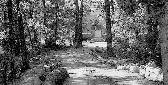
Staff photo by Christine Seymour, |
| The creation of this trail was rather big news in Waltham -- you may read the entire newspaper article about it if you like.
Here are a few additional examples of cut-throughs, also from eastern Massachusetts. |
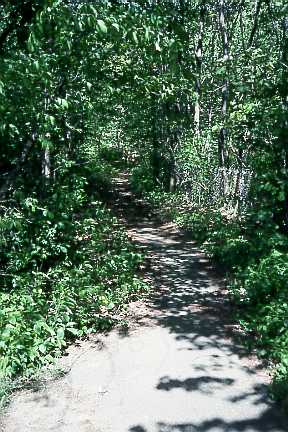
Here, a path around a sewage pump in Framingham, Massachusetts serves as a cut-through between two streets which do not connect with each other. |
 |
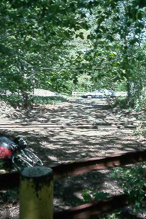 |
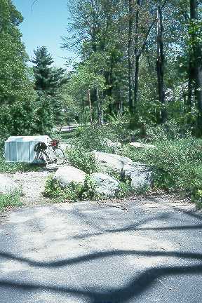
Here, an informal path cuts across the lightly used Framingham-Sudbury railroad line (1 train per week or less). |
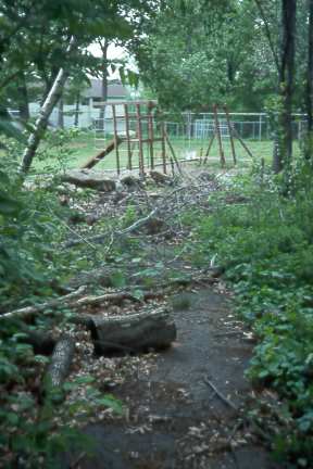
This path leads to a school. It is not well-maintained -- |
 |
 |
In some places, residents have taken matters into their own hands to break through barriers. This fence opening provides access across the Framingham-Sudbury rail line from a municipal sewage pumping station. |
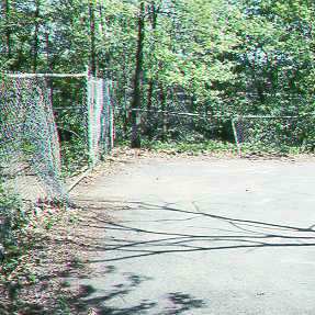
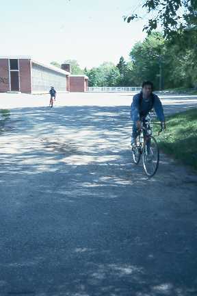
The bicyclists riding past this school, also in Framingham, have been able to reach it from a bicycle/pedestrian cut-through behind the school. Framingham has been very conscientious about providing access to its schools in this way. |
 |
 |
Here in Marlborough, on the other hand, the property rights to a path providing access to a school were apparently not adequately protected. The path has fallen into disuse, and now ends in the back yard of a house which was built more recently than the path. |
Top: home page |
Contents © 2001, John S. Allen |