Top: Home Page
Up: Table of Contents
Previous:
Next:
BEACON STREET, BROOKLINE:
|
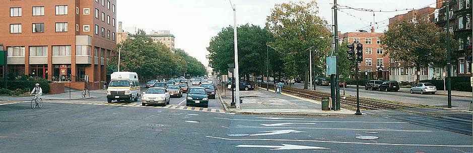
| The panorama below looks back to the east at the intersection of Beacon street with St. Paul Street, a couple of blocks farther into Brookline. There are three westbound travel lanes. This cross-section continues west until Coolidge Corner. |
Looking east on Beacon Street at St. Paul Street.
Scroll right if necessary to view the rest of the panoramic image
|
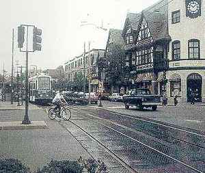
| At Coolidge Corner, the trolley line shifts toward the north side of the median, and
now (looking west in the photo below) there are only two westbound lanes. Thanks to Tom
Dipaolo of the Massachusetts Highway Department for providing a scan of this photo from a
report on proposed Beacon Street improvements. The bicyclist in the photo is riding against traffic on the far side of the median in the cross street. The complicated intersection layout, with the trolley tracks, station platforms and traffic islands may encourage this type of behavior. |
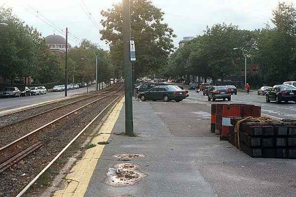
| The next photo was taken from west of Coolidge Corner, looking east. In this stretch Beacon Street is lopsided with more lanes eastbound rather than westbound -- two narrow lanes westbound (toward the camera) and three lanes plus parallel parking eastbound. But in the foreground, you can see that the tracks are meandering back toward the eastbound lanes, and behind where I stood to take the picture, there are once again only two eastbound lanes. |
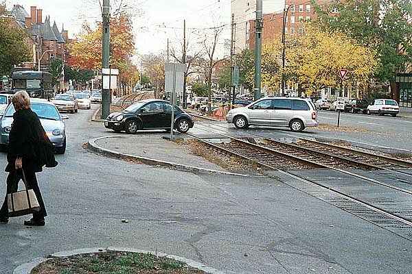
| Between Coolidge Corner and Westbourne Terrace (just
short of Washington Street), the corridor is on a hillside. The westbound lanes are uphill
from the eastbound lanes and trolley tracks. Westbound there are two relatively narrow
lanes, a parking lane and a wide sidewalk behind a row of trees, as shown in the photo
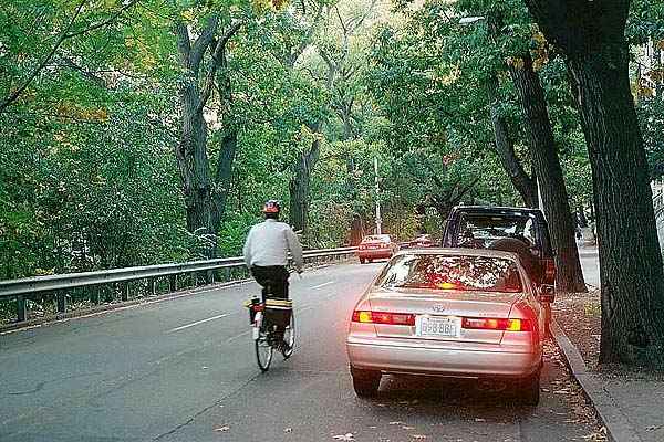
below. The equipment and riding style of the bicyclist in the photo indicate that he is experienced, and comfortable with riding under these conditions even on a heavily traveled arterial. He is claiming the right lane, which is too narrow for him to share. I was standing in the parking lane to take this picture. The car had just pulled in to park as the bicyclist rode by. Improving conditions here would require widening the part of the roadway available for travel. But removing parking spaces would be politically very difficult today, and so would be removing any of the trees, or narrowing the sidewalk. |
| West of Washington Street, Beacon Street returns to the
same cross-section as east of Coolidge Corner, with three lanes westbound and two lanes
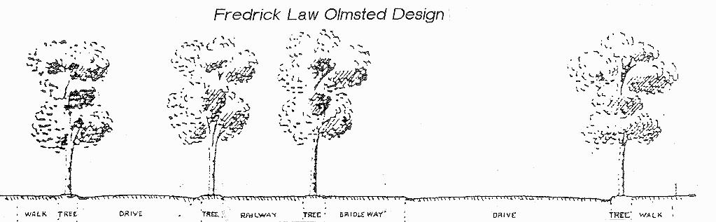
eastbound. What can be done to improve Beacon Street for bicyclists? The problem is difficult, because of the expense of moving the trolley tracks and the political difficulty of removing parking or trees. There were two proposals, one in the 1970s and another in the 1990s, to place a bicycle path in the median. Both proposals were ultimately, and rightly, rejected on grounds that they were too impractical and hazardous. Median bicycle paths do not provide continuous access to destinations at the sides of the street, and they lead to serious conflicts with crossing and turning traffic. These problems are much worse on an arterial with trolleys and station platforms in the median. A high rate of serious collisions between bicyclists and others was to be expected if a median path had been constructed. Interestingly, there once actually was a path in the median. It was part of the original plan for Beacon Street by the renowned designer of public parks, Frederick Law Olmsted. The medians of some Boston-area parkways -- notably Commonwealth Avenue in the Back Bay section of Boston -- have retained their parklike character; some bridle ways in the Boston area, notably that along the Jamaicaway, are still in use as bicycle paths; however, they are not in the median. The area formerly taken by the bridle path in the median of Beacon Street has been converted to angle parking, trolley platforms and landscaped plantings. I do not know how or when this happened, but clearly the bridle path no longer enjoyed political support. There have been some other alterations to the cross-section as well. A recent proposal would again alter the cross-section somewhat. The first image below shows an original Olmsted cross-section, and the second image shows the proposed changes to that cross section. Thanks to Tom Dipaolo again for providing these scans. |
| Scroll right to view rest of image. | Scroll left to read text |
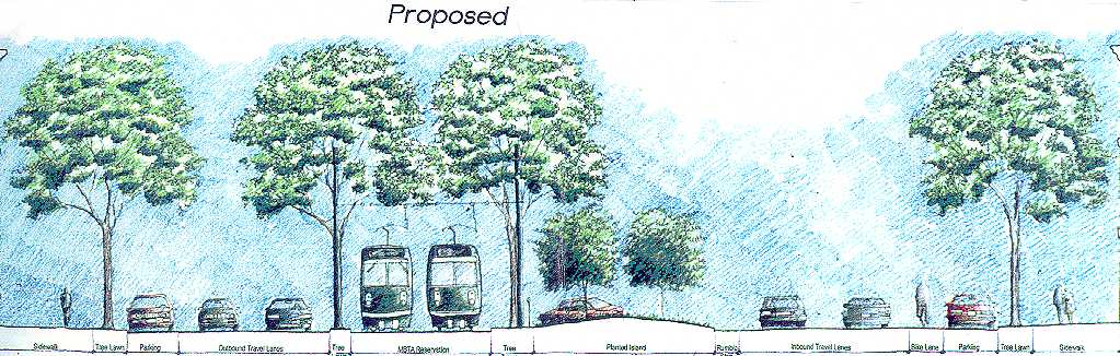
| The most dramatic change is that the westbound roadway
(near the right side of the drawings) is reduced from three to two lanes. The angle
parking area no longer connects directly with a travel lane, but rather with pockets so
cars get in and out of of their parking spaces without interfering with through traffic.
This change will get rid of one cause of frequent collisions. The eastbound roadway (near the left side of the drawings) has been made a couple of feet wider by reducing the separation between it and the trolley tracks. You can see that the width of the raised area under the second tree from the left is narrower in the lower picture. These are real and significant improvements, but there is one thing I find troubling: there is a bike lane westbound -- and none eastbound. My usual concerns about bike lanes apply -- the right side of the bike lane as shown in the picture is in the door zone, as is typical, and there are likely to be additional problems with double-parked vehicles and at intersections. But also, having a bike lane in only one direction may encourage wrong-way bicycling. My preference would be for a wide outside lane, but no bike lane designation. In addition, this cross-section diagram doesn't say anything about intersection design, signs, signals and markings. They are probably covered in the report on the proposed reconstruction. Any major improvement to Beacon Street without decreasing its capacity either for traffic or for parking would require moving the trolley tracks away form one side or the other of the median. Over most of the length of Beacon Street, this option has been foreclosed for the foreseeable future by the decision to maintain and upgrade the angle parking so as to limit the available width for the roadway on the opposite side of the tracks. |