Top: Home Page
Up: Alewife Station area
Previous: Table of contents
Next: Aerial photo


BICYCLE AND PEDESTRIAN
ACCESS IN THE
ALEWIFE STATION AREA,
CAMBRIDGE, MASSACHUSETTS

The Alewife station, the northwestern terminus of the Red line subway line as it was extended in the early 1980s, is a multi-million dollar structure. Most of the expense was for a huge parking garage. The station is near the eastern end of Route 2, a major express highway. The parking garage sees heavy use from commuters who drive in from suburban locations and take the subway for the rest of their trip into Boston.

The station is also near the two residential neighborhoods of North Cambridge and South Arlington. In the original construction of the station, reasonably convenient pedestrian access from North Cambridge was provided, though the route is not very suitable for bicycling -- long and convoluted, difficult to follow and with hazardous blind corners.


Aerial view of the Alewife Station area, showing locations on trails.
Also see larger version of photo in which lettering is readable.

Minuteman trail -- Follow the white line that starts at the upper left, locations D through L in larger photo. Also see panorama of trail north of station with links to descriptions.

Potential alternate links
between Minuteman Trail and
Linear Park: Locations M, N,
top middle, see larger photo.

Fitchburg Cutoff
Path
-- locations A
through C, left
side, also see
larger photo.

alemapsm.jpg (22655 bytes)
 

Alewife Brook Parkway:
locations O, P, Q, see larger photo


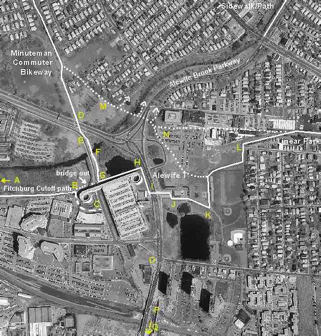
The Fitchburg Cutoff path from the west and Alewife Brook Parkway from the south lead to Alewife station. Access from  Arlington, to the north, was originally via a narrow sidewalk and crosswalk which violate many rules of good design. With the construction of the Minuteman Commuter Bikeway in the early 1990s, the sidewalk and crosswalk were additionally used by substantial numbers of bicyclists. In the mid-1990s, an extension of the Minuteman bikeway was constructed, paralleling the sidewalk from South Arlington toward the station. Pedestrians also use the bikeway extension, which has some disturbing design elements. The crosswalk was not improved.

In the summer of 2001, a temporary plywood tunnel was constructed to protect bicyclists and pedestrians from falling debris during reconstruction of the bridge which carries Route 2 over the bikeway. This tunnel makes it easier for criminals to ambush bikeway users, and a number of crimes have occurred at this location.

It is hoped that the discussion here will avoid similar problems in future projects, and point the way to correction of the problems in the Alewife Station area.


Top: Home Page
Up: Alewife Station area
Previous: Table of contents
Next: Aerial photo

Contents © 2002, John S. Allen ,
except aerial photo, Mass GIS
with additions by Bryce Nesbitt and John S. Allen.
May be reproduced, with attribution.